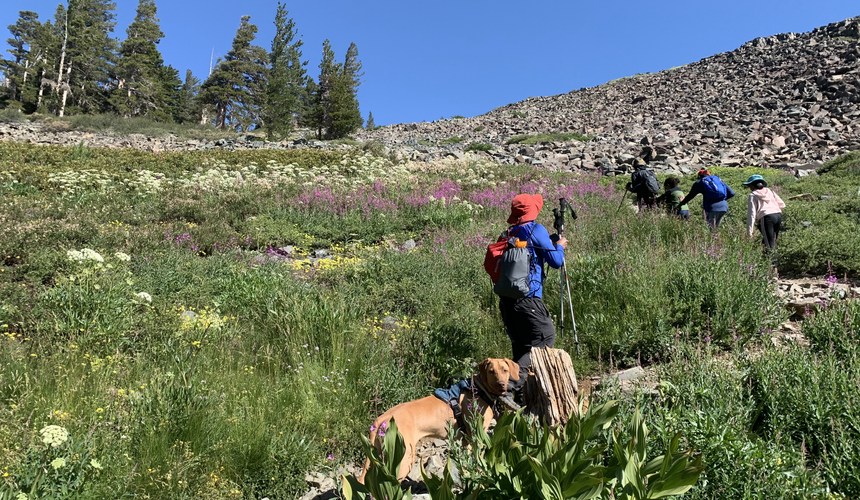
Mount Tallac, South Lake Tahoe California. Must do hike in Tahoe!
- Pawan Sohi
- Aug 12, 2020
- 4 min read
Updated: Oct 9, 2020
Hike the iconic Mt Tallac trail and enjoy spectacular views of Lake Tahoe, Fallen Leaf Lake from 10,000 ft.

The tribe picked Mt Tallac for a hike, given it was doable as a day hike and the bonus being our furry companion was welcome on this trail. This was going to be the first long hike at altitude for some of the junior tribe members and for our furry companion.
Mt Tallac (pronounced til-ACK) is situated southwest of Lake Tahoe in the El Dorado county, and is the most iconic hike in the basin. Wilderness permits are required to enter the Desolation Wilderness both for day hikes and overnight backpacking. Given the tribe was going to make it a day hike, we left Bay Area at around 3AM, this is almost a 3.5 hrs drive to the trailhead. The access to the trailhead is about 3-4 miles from Y intersection of highway 50 & 89 on Mount Tallac Road, which sits opposite of the entrance to Baldwin Beach. When we reached there were only a few other cars parked in the parking lot. The day-use permit can be self issued at the trailhead kiosk, given COVID this requirement was relaxed.
Views of Fallen Leaf Lake, Lake Tahoe, and Desolation Wilderness, this strenuous hike is well worth the effort and not to be missed on a trip to Lake Tahoe.
Starting off from the trailhead, at a short distance trail opens up to the most stunning views of the Fallen Leaf Lake to your left and Lake Tahoe to the far end, this walk is along the ridge through forests with trees shaped with weather. Tribe was lucky to see gorgeous sunrise from this point, sun peaking through the mountains with a soft glow. The trail was rocky right from the get go, with the first 3 miles being relatively moderate, an elevation gain of only around 900-1000 ft. Continuing on we made our first stop at the Floating Island Lake, the water was so clear, literally like a mirror, the reflection of the trees was perfect on the lake. Our furry companion enjoyed looking for fish in the lake. There was another surprise waiting for us about a mile ahead, this was the Cathedral Lake, as stunning as the previous one the tribe enjoyed skipping rocks on the calm surface of the lake. This would make for a perfect dip to tired feet on the way back. After a short break the tribe continued forward.


The real climb on a completely exposed area was ahead of us - a huge mountain of boulders, scree and talus. This certainly was a tough part to navigate, as the trail would get lost in the field of talus, couple of wrong turns on switchback and you have lost the trail. We then realizing there were cairns for navigation. Oh boy were we glad that the sun was not scorching hot on our climb through the talus field. Each step required careful footing, to ensure there is no stepping on loose rocks.

Once past this rocky field, the trail opens up into meadows with beautiful wildflowers, which was completely unexpected. Trail then continues on a steep incline and wraps behind the peak with great views of the Desolation Wilderness. There is a sign for Mt Tallac carved in wood pointing towards the last about 0.2 miles through some really rocky portions where scrambling may be required leading to the peak. You know you made it when the iconic views of Lake Tahoe open up in front. You cannot but admire the shades of blue across Lake Tahoe and Fallen Leaf Lake - absolutely unrestricted views. The tribe enjoyed soaking the view, had a snack and of course took some pictures.
It was time to head back, we wanted to start the climb back while the rocks were still cooler, given our furry companion had done an amazing job navigating over the small, medium and large talus of granite. We wanted to make sure she can head back safely without burns or blisters.


The way down is as tricky as the way up, the rocky trail demands some dedicated focus on the trail and skillful navigation. In fact our junior tribe member got left behind and had some trouble getting down, very thankful to fellow hikers who showed him the way which prevented him getting lost on the steep side of the rocks. On our way back the tribe took some breaks at the two lakes we passed on the way up, the cold water and shade of the trees surrounding the lakes was refreshing.
This is a strenuous hike with limited shade and extremely rocky. However this is also the hike with some of the best views throughout and not something you will forget soon. Unlike what I had read about this being a 9.2 miles RT, our apple devices captured 13.5 miles, so plan accordingly, have plenty of water, even though the breeze was cooler than we expected, dehydration was fast. Ensure you have good hiking shoes with a thick sole, certainly very important on the rocks. Snacks and a good lunch to enjoy at the top is always icing on the cake.
So glad the tribe picked this hike, each member and our furry companion did an amazing job climbing and making beautiful memories. In the words of our junior tribe members "My feet were hurting my legs were hurting but it was all worth it as to see the views and getting to go through an amazing adventure with my friends and family."
Learning's from the tribe - One step at a time, things which seem tough to get to in the beginning are the ones which are the most rewarding.


Comments